
Ficheiro:Adams Block (Crawford, NE).JPG

Ficheiro original (3 620 × 2 580 píxeis, tamanho: 1,74 MB, tipo MIME: image/jpeg)
.JPG)
Descrição do ficheiro
| Descrição |
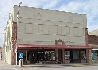
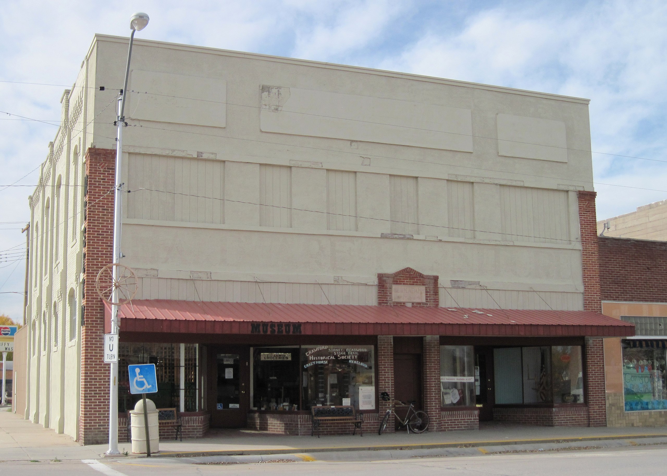
English: Exterior of the Adams Block in downtown Crawford, Nebraska. The edifice was built in 1887, making it the oldest brick structure and one of the oldest buildings in the city. The structure occupies two lots on the northwest corner of Second & Elm Streets. It was refronted in 1930, hence the problematic stucco. The brick on the side of the building is original, however.
The south (left) side of the building housed a hardware store for about 90 years and the north side housed a general merchandise establishment before becoming a furniture store. The upper story was used for offices and "gentlemen's entertainment". However, the upstairs was never updated for electricity or running water and was later used for storing the furniture store's surplus goods. The structure was purchased by the Crawford Cultural Center group in the 1970s. The north (right) side of the building was occupied by Crawford RSVP (which still uses the space, as of 2012), and the south side was used as the senior center before being utilized in 1991 as the Crawford Historical Museum (also still active), run by the Crawford Historical Society. Although the lower story has been kept up fairly well, the upstairs has fallen into a state of dilapidation due to neglect; however, the windows and access door have been closed up to prevent further damage. The additions on the rear of the building, constructed probably about 1910, are used for storage. Surprisingly, the structure does not have a basement. The Adams Block is now owned by the city, which is housed across the street behind the bank. Both organizations currently occupying the building remain active. |
| Data | |
| Origem | Obra do próprio |
| Autor | Chevsapher |
| Localização da câmara | | Esta e outras imagens nas suas localizações em: OpenStreetMap |
|---|
.JPG¶ms=042.685833_N_-103.413333_E_globe:Earth_type:camera_region:US_&language=pt)
Licenciamento
| A utilização deste ficheiro é regulada nos termos Creative Commons - CC0 1.0 Dedicação Universal ao Domínio Público. | |
| A pessoa que associou uma obra a este documento dedicou-a ao domínio público, renunciando a todos os seus direitos sobre a obra em todo o mundo ao abrigo da legislação de direitos de autor, incluindo a todos os direitos legais conexos, na medida permitida por lei. Pode copiar, modificar, distribuir e executar a obra, até com fins comerciais, sem pedir autorização.
|
| Anotações | Esta imagem está anotada: Ver as anotações na wiki Commons |
Histórico do ficheiro
Clique uma data e hora para ver o ficheiro tal como ele se encontrava nessa altura.
| Data e hora | Miniatura | Dimensões | Utilizador | Comentário | |
|---|---|---|---|---|---|
| atual | 20h17min de 29 de abril de 2012 | | 3 620 × 2 580 (1,74 MB) | Chevsapher |
Utilização local do ficheiro
A seguinte página usa este ficheiro:
Utilização global do ficheiro
As seguintes wikis usam este ficheiro:
- Uso no domínio en.wikipedia.org
- Uso no domínio en.wikivoyage.org
.JPG)